
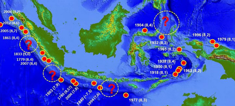
ZOAHARIAN.COM – The potential for large earthquakes in Indonesia has become a concern again after the update of the 2024 Indonesian Earthquake Hazard and Source Map shows that there are 14 megathrust zones.
This number has increased compared to the previous map published in 2017. In the latest map, a number of areas also show a higher level of earthquake danger with the contours of potential shocks getting denser.
This condition is also of concern to an earthquake expert from Japan, Professor Kosuke Heki from Hokkaido University. He saw that there were geological characteristics that were similar between a number of subduction zones in Indonesia and the Nankai Trough in Japan.
The Nankai Trough is one of the active megathrust zones in Japan which has long been the object of research related to large earthquakes and deformation of the earth's crust.
"We understand that magnitude 8 earthquakes in Japan occur at intervals of around 50 to 100 years. This is our classic view before a large earthquake occurs," said Heki when he was a Visiting Researcher at the National Research and Innovation Agency (BRIN) at the end of December 2025.
Monitoring Is Key
According to Heki, the timing of a large earthquake cannot be predicted with certainty. Therefore, long-term monitoring of deformation of the earth's crust is an important part of mitigation efforts.
Global Navigation Satellite System (GNSS) technology and seabed geodetic measurements can be used to monitor changes in the earth's crust as well as help understand the process of stress accumulation in subduction zones.
"We see interlocking interseismic coupling almost along the trench axis. Even in very shallow parts of the plate boundary, strain continues to accumulate for the next earthquake," he explained.
Heki also highlighted the phenomenon of a slow slip event, namely a shift or release of energy in a plate area that occurs slowly.
This phenomenon has been observed several times in the Nankai Trough and other areas of Japan. According to Heki, the existence of slow slip events is an important phenomenon to continue studying because it can be related to the process leading to a large earthquake.
"This phenomenon has been observed repeatedly in the Nankai Trough and other areas of Japan. One of these slow shifting events could trigger the next large earthquake," he said.
Indonesia has many subduction zones
Indonesia has a number of active subduction zones stretching from Sumatra, Java, Bali, Lombok to Maluku.
Heki assesses that this condition opens up opportunities to develop a more comprehensive system for monitoring deformation of the earth's crust. Strengthening the GNSS network and seabed observation technology can help produce data regarding plate movements in more detail.
"Currently I am working on this problem in Indonesia," said Heki.
There is a Megathrust with Potentially Large Magnitude
In the 2024 Indonesian Earthquake Hazard and Source Map, a number of megathrust zones have very large maximum magnitude values.
The Aceh-Andaman Megathrust Zone is recorded as having a maximum potential magnitude of up to M9.2. Meanwhile, the Java Megathrust has a potential of up to M9.1.
Apart from that, the Mentawai-Siberut, Mentawai-Pagai and Enggano zones are each recorded as having a maximum potential magnitude of around M8.9.
This magnitude number does not mean that an earthquake with maximum strength will occur in the near future. This value is an illustration of the maximum potential based on a study of earthquake sources and tectonic conditions.
BMKG: Seismic Gap is Not a Prediction of Earthquakes
The Meteorology, Climatology and Geophysics Agency (BMKG) previously also highlighted the existence of zones called seismic gaps, including the Sunda Strait and Mentawai-Siberut.
These two areas are of concern because they have a history of large earthquakes and have not experienced large-scale energy releases for a long time. The last major earthquake as a reference occurred in 1757 in the Sunda Strait and 1797 in the Mentawai-Siberut region.
However, BMKG emphasized that the term "waiting time" does not mean that an earthquake will definitely occur in the near future.
"What is meant is the accumulation of energy that is still stored because a large earthquake has not occurred for a long time. This does not mean that an earthquake will occur in the near future," wrote BMKG in its statement.
Thus, the existence of 14 megathrust zones must be understood as an illustration of Indonesia's tectonic conditions as well as a reminder of the importance of preparedness. Until now, the exact time, location and strength of the earthquake cannot be predicted.
Comment (0)
No comments yet. Be the first!
Leave a Comment